Accession No
2852
Brief Description
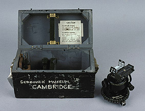
rock compass, adapted from a star-compass for use by Brian Harland, 1940 (c)
Origin
Maker
Class
earth sciences; magnetism
Earliest Date
1940
Latest Date
1940
Inscription Date
Material
metal
Dimensions
box length 266mm; breadth 139mm; height 163mm
Special Collection
Provenance
Transferred from Sedgwick Museum, Department of Earth Sciences, University of Cambridge, Cambridge, England, 05/1982.
Inscription
‘SEDGWICK MUSEUM’ (painted on instrument)
‘S44’ (painted on instrument)
‘S44’ (painted on box)
‘SEDGWICK MUSEUM
CAMBRIDGE’ (painted on box)
‘28 Jun 1944’; ‘20 Oct 1945’ (stamps in box with dates legible)
‘A1’ (on instrument)
‘A2’ ( on instrument)
‘A3’ (on instrument)
Description Notes
Adapted star compass. Open sights pivot over declination scale divided 62-1-62 by 1o (62-0-62 by 2o?, 10-1-2000). Reverse of declination arc now fitted with trough compass. Compass scale reads 5-0-5 by 1, at either end. Two bubble levels mounted on plate rotating (by knurled screw) over right ascension scale divided 0-360 by 1o (by 2˚?, 10-1-2000), lower scale with same division but opposite calibration. Upper portion mounted on two vertical plates and adjustable for latitude by knurled screw. Latitude scale divided 0-9(S)-0(N) with drumhead divider 0-10(S) and 10-0(N). Horizontal circle divided 0-360 by 1o (by 2˚?, 10-1-2000). 3 feet. Fitted in box with tools.
Condition: fair.
References
Events
Description
Magnetic compass
The magnetic compass consists of a magnetic needle attached to a compass card, graduated into angular points, and is used for navigation. The first known dry pivoted compass is dated as early as 1269.
The compass indicates the direction of the magnetic pole but there are problems caused by the difference between magnetic and true north (true north being the useful reading). The variation between the two must be calculated in order to obtain an accurate reading. True north was sometimes simply offset from the direction of magnetic north, but this did not allow for geographical variation. For this, charts were needed. The iron used in building ships during 19th century also led to problems because the magnetism of iron affected the compasses on board.
18/10/2002
Created by: Saffron Clackson on 18/10/2002
FM:42141
Images (Click to view full size):