Accession No
1468
Brief Description
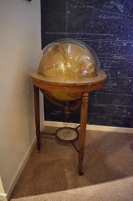
18-inch terrestrial globe, in wooden floor stand, by J. and W. Cary, English, 1842 impression of 1816 edition
Origin
England; London; Strand
Maker
J. and W. Cary
Class
cartography
Earliest Date
1842
Latest Date
1842
Inscription Date
1842
Material
paper; glass; wood; metal (steel, brass)
Dimensions
height 1118mm; diameter 626mm
Special Collection
Provenance
Donated by Park Street School, Cambridge, in 1965.
Inscription
‘CARY’S
NEW
TERRESTRIAL GLOBE,
EXHIBITING
The Tracks and Discoveries made by
CAPTAIN COOK
also those of CAPTAIN VANCOUVER on the
NORTH WEST COAST OF AMERICA;
And M. DE LA PEROUSE, on the COAST of TARTARY
TOGETHER
with every other improvement collected from
Various navigators to the present time
LONDON
Made and sold by J & W Cary, Strand, March 1st 1816’ (cartouche)
‘WITH ADDITIONS AND CORRECTIONS TO 1842.’ (below cartouche)
Description Notes
18-inch terrestrial globe, by J & W Cary, London, 1842 impression of 1816 edition. Plaster sphere with printed paper gores.
18 engraved and hand-coloured gores; polar axis; brass hour circle divided I - XII, I - XII, numbered by I, subdivided to 5 minutes. Brass meridian circle divided 0 - 90˚ - 0 , 90˚ - 0 - 90˚ from poles, numbered by 10˚, subdivided to 15´. Wooden horizon circle with 4 piece printed calendar plate. Meridian circle clamp. Set in tripod cradle with fluted wooden legs on castors. Compass below globe, suspended between legs. 32-point printed paper rose divided 0 -90˚ - 0 - 90˚ - 0 and 0 - 360˚, numbered by 10˚, subdivided to 1˚. Glazed (originally with cracked glass - after this was removed a new piece of glass was added on 02/06/2009. See ‘conservation history’ field for more information).
References
Events
Description
Terrestrial globes modelled the Earth’s movements in relation to the stars, Sun and Moon, and promoted interest in exploration and charting the surface of the globe. Having been used as aids for sea merchants since the twelfth century, the role of maps in navigation practices had been well established by the seventeenth century; however, by the end of early modern period the use of globes as navigational tools diminished. In the nineteenth century, the role of the globe turned from astronomical to geographical study as the importance of the Earth’s surface was increasingly emphasized. During this period, terrestrial globes were used increasingly as teaching aids for geography lessons. This example was previously owned by the Part Street School in Cambridge, England, and was likely used in teaching demonstrations. It is an 1842 impression of Cary’s 1816 edition, which was amended to be correct and up-to-date. The globe was produced by the instrument maker and map publisher John Cary (1755–1835) and his brother William Cary (1759–1825); the Cary firm became the leading globe-making producer in nineteenth-century Britain. In 1770, John began his apprenticeship to William Palmer of New Street Square London, and became a freeman in 1778. Three years later, John opened his globe-making business and convinced William to join him in the production of globes and planetaria; however, the two brothers maintained separate businesses with other projects.
14/01/2014
Created by: Allison Ksiazkiewicz on 14/01/2014
FM:45478
Images (Click to view full size):