Accession No
6215
Brief Description
printed paper and card celestial planisphere, by G. Thomas, after the celestial charts of Camille Flammarion, French, 1890 (c)
Origin
France; Paris; 44 Rue N.D. des Champs
Maker
Thomas, G.
Class
astronomy; demonstration
Earliest Date
1880
Latest Date
1899
Inscription Date
Material
paper (paper, card); organic (string); metal (brass)
Dimensions
length 560mm; width 560mm; depth 10mm
Special Collection
Provenance
Purchased from Bonhams, Montpelier St., Knightsbridge, London, SW7 1HH on or before 28/11/2007. Lot 128 in ‘Science and Marine’ sale.
Inscription
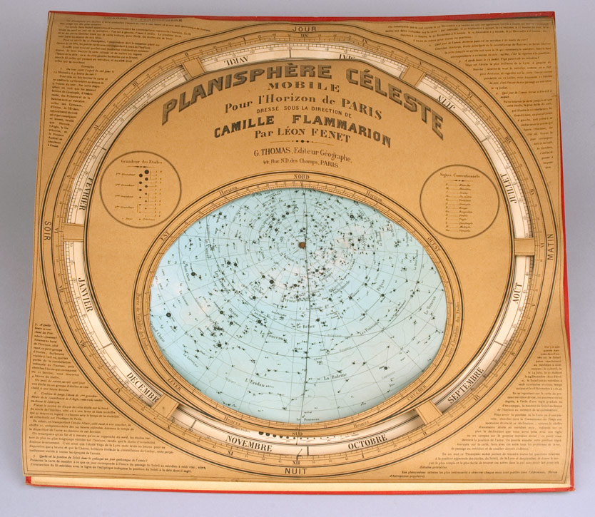
“Planisphère Céleste mobile Pour L’Horizon de Paris dressé sous la direction de Camille Flammarion par Léon Fenet, G Thomas, Editeur Géographe, 44 Rue N. D. des Champs, Paris”
Description Notes
Printed paper and card celestial planisphere by G. Thomas; French; late 19th century.
Circular card dial, printed with the constellations on a blue background. Rotates around a brass pin in the centre. Card surround has apertures for calendar and map of the heavens, and is printed with French instructions for use. Card backboard is edged in red, textured (possibly vinyl coated) paper. Has two rings at the top for hanging the planisphere.
Original string is present, but broken. String originally ran north to south along the elliptical window of the planisphere.
Condition fair; cardboard base showing some warping - all four corners lifted. Paper surround very warped. Some discolouration to paper on base. Abrasion to paper covering backboard in lower right corner. Tear to paper bridging cutout section on left side, just above the word ‘soir’.
References
Events
Description
Celestial planisphere
A planisphere is a device that shows the groups of stars (constellations) that can be seen in the sky at any time of the year in a particular location.
Different stars are visible in the sky depending on where you are on the earth’s surface. A planisphere is therefore designed for a certain area, showing the stars visible in that particular latitude zone (the position above/below the equator).
A planisphere consists of a star chart, i.e. a map of the sky, with the days of the year around the edge. The star chart is attached at its centre to a circular overlay with the hours of the day around the edge. The overlay has a window or hole so that only a portion of the sky will be visible in the window at any given time. Both parts are mounted so that they are free to rotate about a common pivot point at their centres. By lining up the correct date with the time of day you will get a map of what you can see in the sky at that time.
Since the planisphere shows the three-dimensional night sky on a flat surface, there is some distortion of distances and/or area, depending on what ‘projection’ is used to map the celestial sphere onto the plane surface.
15/04/2008
Created by: Ruth Horry on 15/04/2008
FM:46686
Images (Click to view full size):