Accession No
1080
Brief Description
sextant, by Edward Nairne, English, 1773 (c)
Origin
England; London
Maker
Nairne, Edward
Class
navigation
Earliest Date
1749
Latest Date
1774
Inscription Date
Material
metal; glass; brass; wood
Dimensions
radius 160mm; index arm 210mm box length 230mm; breadth 260mm; height 70mm
Special Collection
Provenance
On loan from St. John’s College, University of Cambridge from 08/1951.
Inscription
Edwd. Nairne London (support strut)
Description Notes
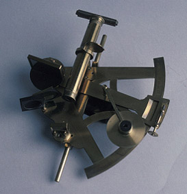
Sextant, by Edward Nairne, English, 1773 (c).
Sextant. Plate brass frame. Wooden handle fixed in brass mount. Removable brass cross piece. Adjustable index mirror with three coloured filters. Horizon glass with level adjustment. Alternative telescopic and pinhole sights with lateral adjustment (screw missing). Shadow on eyepiece. Index scale divided clockwise [6˚] - 0 - [139˚], numbered by 10˚, subdivided to 5˚, to 1˚ and to 30´. Brass index arm with clamp and tangent screws and type-B vernier on brass divided clockwise [0] - 30´, numbered by 5´, subdivided to 1´. Reading glass on subsidiary arm attached to index arm.
Step wooden box
Key for this instrument may be on bunch of keys for St. John’s instruments. See location note and notes fields for more information.
References
Events
Description
The sextant is a very effective tool which took quite some work to construct. They were most commonly used at sea to find the angle between two objects which then could be used to find your latitude.
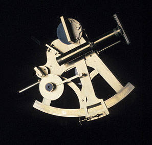
Invented in the early 1700s, they were originally made out of wood. But these had a tendency to warp and split and so weren’t very reliable or sustainable. When they started being mass produced for the navy, they were made out of brass; despite being heavy it gave them a great amount of stability so they wouldn’t wiggle as much in your hands while the boat rocked. This made them very accurate. In hot climates, the sextant would be painted white to reflect the heat so that the glass didn’t warp and ruin the readings. Unlike most modern tools like GPS it doesn’t require electricity to function. That why this excellent piece of kit is still used as part of the modern navy’s training and is featured in their exams too.
Do we have a tendency to rely too much on technology with nothing to fall back on if that fails?
[Label written by work experience student Jack in 2019]
26/09/2022
Created by: Morgan Bell on 26/09/2022
Description
Today navigation instruments such as radar, radio and satellites update a ship’s position continuously. During the 17th and 18th centuries manual calculations had to be made using instruments such as the backstaff, octant or sextant.
The term “sextant” refers to an arc of 60°. The sextant is a portable instrument that measures angles between distant objects. It is an instrument that has been used in the fields of astronomy, surveying and navigation. When navigating, the sextant is used to measure latitude to an accuracy of 0.01 of a degree. To use the sextant the navigator moves the index arm until the index mirror appears to line up the sun within the horizon mirror. By reading the angle off the index arm, the angle of the sun (and therefore the ship's latitude) can be calculated.
Much thought was put into the design for the sextant in an attempt to make them as accurate as possible. The first examples of sextants were made of brass and were mostly large and heavy. Over time the frame was designed to be rigid and light. A successful and popular design in the 18th Century was the “double-frame” or “pillar frame” sextant which was patented by Troughton in 1788. An example of this sextant can be seen in the navigation case.
The Search for Longitude
The sextant was also used in an attempt to determine longitude as well as latitude. In the 1750’s Tobias Mayer’s design of a reflecting circle was given to the British Board of Longitude who gave the instrument to Captain John Campbell to test fully at sea. Campbell liked the idea but found the circle too awkward to use. John Bird was ordered by Campbell to design a 60° arc (the sextant), which he thought to be adequate for the longitude measurements required. (To discover more about the search for longitude have a look at some of the books).
FM:39666
Images (Click to view full size):