Accession No
4562
Brief Description
planisphere, by J. Reynolds, English, 1850 -1940
Origin
England; London; 174 Strand
Maker
Reynolds, J. Rock and Company Reeves and Sons Peacock and Mansfield
Class
cartography; demonstration; ephemera
Earliest Date
1850
Latest Date
1940
Inscription Date
Material
paper (card and one other)
Dimensions
height 227mm; breadth 287mm
Special Collection
Provenance
Purchased on 30/10/1996.
Inscription
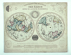
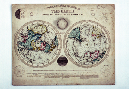
GEOGRAPHICAL DIAGRAM OF THE EARTH ADAPTED FOR ILLUSTRATING ITS MOVEMENTS &C. (top)
London: Published by J. Reynolds. 174 Strand. Rock & Co. Reeves & Sons. Peacock & Mansfield.
Description Notes
Geographical diagram of the Earth, comprising two paper planispheric maps of the north and south terrestrial hemispheres which rotate on a card background giving a time scale.
Printed card sheet to which the two revolving hemispheres are attached by knotted green thread at the centre. Northern hemisphere is left centre, southern hemisphere right centre. Time scale is twice XII-I for both, with ‘Noon’ marked at the top centre and ‘Night’ opposite, ‘Morning’ and ‘Evening’ at VI. The hemispheres are coloured with blue, red, and yellow, with the ‘British Dominions Colored Red’, and the ecliptic line is marked on each with the label ‘Vertical place of the Sun for each day in the year’ and calendar divisions. About the two hemispheres are several other diagrams: ‘The Phenomena of Day and Night’; ‘Summer & Winter Altitudes of the Sun in the Latitude of London’; ‘Meridians of Longitude’, ‘Zones’, and ‘Parallels of Latitude’. Beneath the hemispheres is written ‘By means of this Diagram may be performed most of the Problems executed upon a terrestrial globe of which the following are examples’ with four tasks listed. The whole is in fair condition, with some folding damage, dirt marks, and slight water discolouration.
References
Events
Description
This geographical diagram of the Earth is comprised of two planispheric maps of the north and south terrestrial hemispheres. These two maps rotate against a card background, providing a measurement of scale. The hemispheres are coloured with blue, red, and yellow, with the British dominions colored red. The ecliptic line is marked on each with the label ‘Vertical place of the Sun for each day in the year’ along with calendar divisions. On the background surrounding the two hemispheres are several other diagrams: ‘The Phenomena of Day and Night’; ‘Summer & Winter Altitudes of the Sun in the Latitude of London’; ‘Meridians of Longitude’, ‘Zones’, and ‘Parallels of Latitude’. Beneath the hemispheres it is written: ‘By means of this Diagram may be performed most of the Problems executed upon a terrestrial globe of which the following are examples’. Four tasks are listed.
24/02/2014
Created by: Allison Ksiazkiewicz on 24/02/2014
FM:40244
Images (Click to view full size):