Accession No
2855
Brief Description
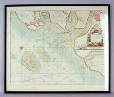
printed and coloured sea chart of Harwich, after the work of Hydrographer Greenvile Collins, English, dated 1686 but likely later printing [c. 1770?]; framed
Origin
England
Maker
Collins, Greenvile [Hydrographer]
Class
prints; navigation; cartography
Earliest Date
1693
Latest Date
1770
Inscription Date
1686
Material
paper; wood; glass
Dimensions
breadth 640mm; height 534mm
Special Collection
Provenance
Purchased from Robert Douwma Prints & Maps, Great Russell Street, London, England, 1982.
Inscription
‘HARWICH
Woodbridg and Handfordwater
with the Sands from
the Nazeland to
Hosely Bay’ (top right hand corner)
‘To ye Honble:
SAMUELL PEPYS Esqr
Secretary of the ADMIRALTY of
ENGLAND
President of ye Royall Society &
Master of ye TRINITY HOUSE of
Deptford: Strond.
This Chart is Dedicated and Presented
by Capt. GREENVIL COLLINS.
Hydrogr to the KING 1686’ (RHS of chart)
Description Notes
Printed and coloured sea chart of Harwich, after the work of Hydrographer Greenvile Collins, English, dated 1686 but likely later printing [c. 1770?]. Framed.
Coloured copper engraving taken from the Coasting Pilot, the first sea atlas of British waters to be based on an entirely English hydrographic survey. The charts were designed for practical use but nevertheless have some ornate cartouches around the title. Some black smudges and a repaired tear on the left edge.
Condition good; complete; framed.
References
Events
FM:40969
Images (Click to view full size):